In just three short years, this has become the rally that I most look forward to and this year proved no different. Everything from the day the rally is announced to saying goodbye to everyone Sunday morning is top notch. And this coming from two rallymasters that cannot be more different from one another - Gary - the tall and quiet type, but be sure to listen to every word he says when he does talk and Scott - well, let's just say he can both shock and impress you at the same time with his directness and quick wit. Scott yearns to be front and center during the rally while Gary is quietly hanging in the background. However, the two of them make the 30 hours (give or take) the most enjoyable time you can have on the bike chasing after bonus locations.
The timing of this rally is always around the Columbus Day weekend and generally corresponds to near the peek of the leaf turning colors in West Virginia, Western Maryland, and Southern Pennsylvania which results in both positive and negative aspects. By far the most positive aspect is the incredible colors and scenery we get to enjoy during the rally. Typically, the late afternoon and early evening on Friday will present itself some incredible vistas to see Mother Nature in all her splendor and the early Saturday morning hours greet you with a new day and the colors popping back to life with the sunrise. However, the negative is that you are not the only one out on the road to enjoy the scenery so traffic, congestion, and fall festivals in small towns restrict you time; as well creates some interesting challenges in finding a place for your rest bonus. This year's bonus list made sure that both the positive and negatives were going to be in play throughout the rally.
As in the past, the rally book came a day earlier than the website promised. However, this year it showed up at 1:30 p.m. on Tuesday afternoon - right before I was off to a lunch meeting. Do you know how hard it is to have a productive lunch meeting when all you want to do is rush back to the office and start tearing into the rally book and bonus locations??? I think that I pulled it off and was back in my office a little after 3 p.m. trying to figure out the twists and turns of the route. In going through it, it was clear that past years scoring marathons was not going to be repeated and the rallymasters were going to keep you on the clock until you turn in your scoring packet. So not only do you have to get back to the hotel before 2 p.m., but you needed to have all of the paperwork done. A great concept and one that worked incredibly well in my opinion and I hope that they continue this. By staying on the clock you had to make sure to leave you enough time to prepare the paperwork - though the question is how much time do you need? 15 minutes seems about right for me since I stay pretty organized during the rally and clearly know where and when I was at during the rally. But I wanted a little bit of cushion so I decided to route my course to ensure that I have at least 30 minutes.
The rest of the rally book seems surprisingly straight forward. Take a picture of this, read the inscription and fill in the blank, make sure you rest for at least three hours, etc. With each page, I keep looking for a pitfall but I just can't find one. Through all of the e-mails leading up to the release of the rally book, Scott and Gary kept stressing reading comprehension. So there must be something hidden here. Nope, nothing. So realizing that all I have to do is follow the directions at each bonus, I should score pretty well once I find a route that I like.
I first zoom in on the three combo bonus - bonus locations that when grouped together you get not only the bonus but extra points for collecting two or three of the like bonus locations. The combo locations are mostly located in South Georgia and then up the east coast. I quickly calculate that the combo points are nice, but there are not a lot of extra bonus locations along that route. So that means you will either have a lower score or will have to ride a lot of extra miles to get other bonus locations. Next I look to the west. I quickly realize that is a big waste of time. So I move on to a northern option. There are more bonus locations in the north than one has time for, so I need to whittle it down. I wanted to maximize my points while keeping the mileage around 1200 miles. The route that I quickly zeroed in on, had me beeline it up from Statesboro, GA into West Virginia/Western Maryland, and Western Virginia pretty quickly in the day after hitting some bonus locations not too far from the direct route to Wytheville, VA. Overall, it appears to be a 567 point route with about 1,220 miles and will allow for a 4 hour rest bonus. So I load it into the GPS, pack up the bike, and wait until Thursday to head to Statesboro.
After a half of a day's work on Thursday, I make my way down to Statesboro about 3 hours south of Athens. The ride down is beautiful as the beginnings of fall start to make their way into the Georgia countryside. I purposely stay off the interstate and have as much of an enjoyable ride as possible, while still making good time. While checking into the hotel, I am already meeting up with fellow riders and friends that I haven't seen since the last rally. We all head off to dinner and after a short detour (whoever heard of a steakhouse that doesn't serve beer??? Oh yeah, it is South Georgia), we land at a Mexican restaurant. Given the size of the group, we have to break up and I find myself sitting with a number of riders who are riding in the IBR next summer so most of the conversation centers around that ride. I am very interested in the IBR (11 days, 11,000 miles). It is something that I don't think I will ever do, but hats off to all that attempt it.


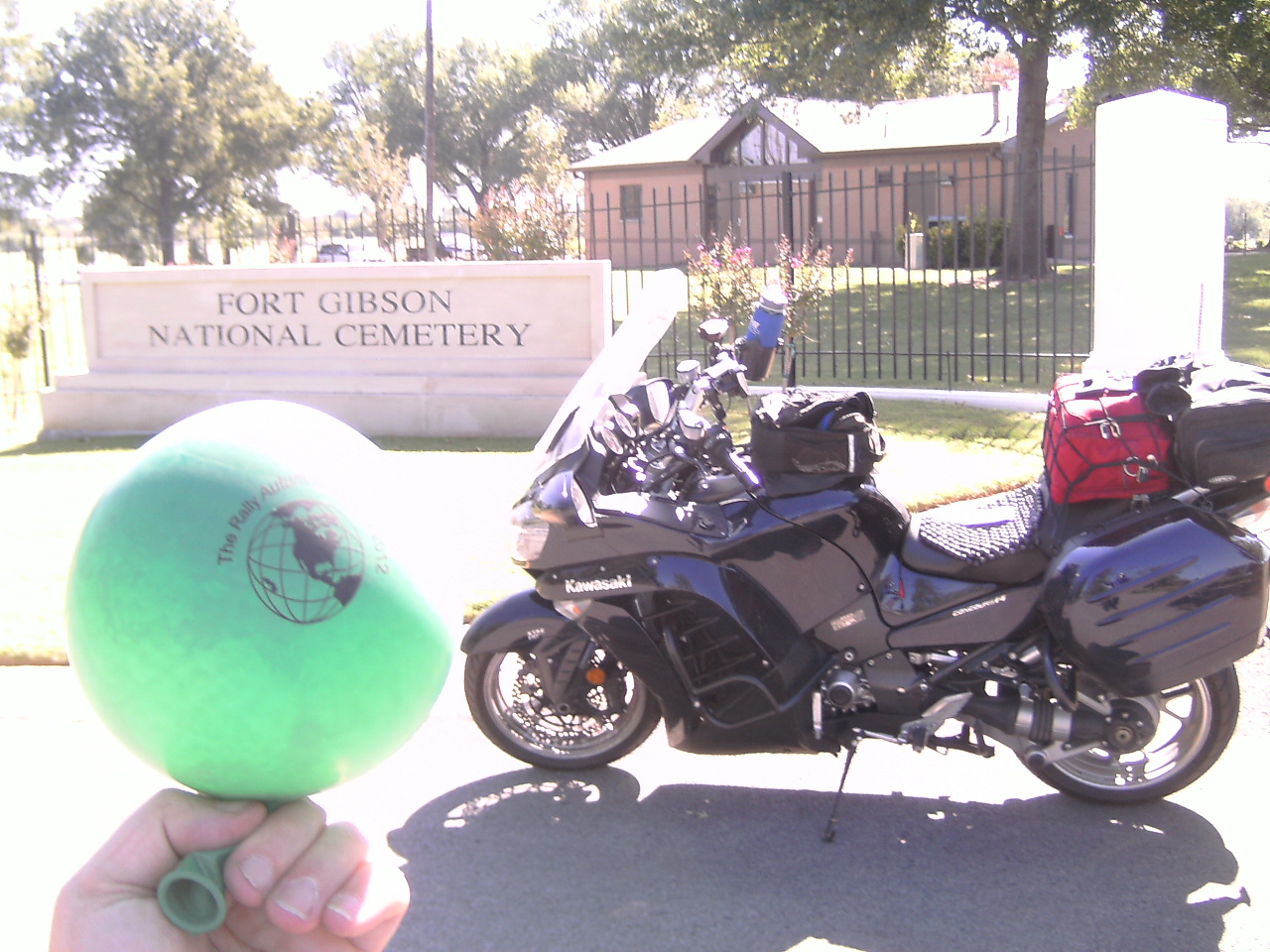
 Friday morning arrives and I head out to the starting gas station that I found on my way into Statesboro yesterday afternoon. It is located on my route about 10 minutes north of the city (while still recording a Statesboro address) so I am starting my rally 10 minutes ahead of schedule already! Can't get much better - but of course when I get my start receipt, the pump works fine but is out of paper. So I have to shuffle into the store to check a duplicate. All is good and I text in my starting information and head north on US 25 towards Augusta. The first stop is the Granitesville Cemetery Historical Highway Marker that is actually within the cemetery grounds. I stop take the picture, wave to Rick and Barbara who wind up right behind me and then point the bike towards Ninety Six, SC about 50 miles north of here. I have been to this bonus location (and the next one) before and know the roads pretty well since I have ridden them in the past (on personal rides as well as rallies) so I feel confident that I will be able to get quite a bit ahead of schedule to maximize my rest bonus. My stops in Ninety Six and then Ridgeway (home to the World's Smallest Police Station) are bagged easily enough and I am considerably ahead of schedule and feeling really good with the direction of my rally so far.
 From Ridgeway it is an easy afternoon ride up I-77 into Charlotte. Traffic for the most part remains light as I enter into North Carolina and really does not pick up until I am closing in on Concord just north of the city. At about the same time the GPS tells me to get off I-85 and head to the surface streets, traffic on I-85 comes to a halt. Therefore, I decide to follow Ms. Garmin and make my way to the speedway via the local roads. As I approach the speedway (I love the sheer magnitude of size of these stadiums), I start thinking about the bonus location (a specific gate) and realize that it will likely be on the backside of the course since rallymasters are devious that way and sure enough it was. But the speedway was deserted and I quickly made my way around to the back side and snap the required picture and still 25 minutes ahead of schedule. I am already making plans for a solid 5 hours of sleep in my head.
 While escaping the Charlotte traffic, I enter into a work zone just outside of Statesville and notice a line of police cars near the front of the group of cars about 10 vehicles ahead of me. I am not sure what all transpired but as soon as we cleared the work zone, the lights come on and they start pulling over all of the vehicles who were traveling at the front of the line. Once I make my way past that excitement, it is open roads into the mountains of southwest Virginia and the colors really start becoming vibrant. Coming into Virginia, the temperatures start to drop a little but the clear, crisp air makes up for it but providing my wonderful vistas and overlooks down to the farming valleys below I-77. Making my way into Wytheville, I remain well ahead of schedule and snap the picture of the large pencil and then point the bike into West Virginia.
 Now is when the trip becomes really exciting, it is late afternoon and the sun is slowly setting off to my left as I travel north on I-77 through the mountains of southwest Virginia, through the tunnels into West Virginia, and then up the spine of the state (though one of Ms. Garmin GPS units wanted me to get off I-77 - I wasn't falling for that). The colors are simply exploding around me, the air remains clear and crisp and traffic is very light. So I am making incredible time while having the most relaxed ride up I-77 and then eastbound on I-64 towards Lewisburg. The next bonus location is just off downtown which appears to have only one way into and out of from the north and I-64. Traffic is pretty slammed once I get off the interstate and resolve not to come out the same way I am going in. I find the required bell after a short loop around the outside of the park and head the bike even further to the east while bypassing the traffic head towards the restaurants and strip malls north of downtown near I-64 . I am now almost 45 minutes ahead of schedule. Yahoo!!!
 It is now pushing 7 p.m. and the sun is quickly being lost behind the mountains and the shadows of the valley start to surround me and push me and the road into darkness. As I head into the Jefferson National Forest to search out the Roaring Run Furnace, it so spooky with the overhanging trees that I am convinced this is where the Blair Witch Project was conceived. There is still a little bit of light up in the sky, but the ground and road is dark as can be. I have decent night lights on the bike, so I stay fairly confident that I can follow the road, but do ease back a bit on the throttle. I get to the pull off for the furnace and find it to be a dirt/gravel roadway. About a mile in, the road ends at the necessary gate now about 30 minutes ahead of schedule. I snap the picture and head out of the forest thinking that the worst of my route is behind me. Hah!
Before leaving the house, I routed my route in both Google Maps as well as Streets and Trips to see how it was going to send me through the mountains. They both were in agreement, so I figured Ms. Garmin would as well. So upon leaving the Furnace, I blindly follow her into Clifton Forge before turning onto a series of residential streets. Passing a sign warning of severe curves and recommending not following the GPS route, I quickly realize that this is going to be a difficult journey in darkness. Sulpher Springs Road is where Ms. Garmin has me heading with all of her switchbacks and lack of center/edge lines. I don't pass another vehicle on the road in all the 30 minutes for the 15 miles that I travel on her and convinced if I go over the edge I will never be found. I finally make my way onto US 220 after giving up all of my time that I was ahead of schedule. It actually was probably a pretty neat road in the daytime, but at night, backtracking to US 220 once leaving the Furnace would have made much more sense.
 US220 is a relatively easy road to keep up some decent speeds on, but after the draining 30 minutes on Sulpher Springs, I find it difficult to push it that hard. Plus Bambi starts to make her appearance so I am constantly staying vigilant for the unexpected crossing. Fortunately, she stays off to the side of the ride when I pass. One interested thing about these rallies is that you come across the darnest things along the way. US 220 is deserted and from what I can make out is very rural. But as I turn into Hot Springs, VA, I am greeted by the largest mansion I have ever seen in the middle of nowhere. It is called The Homestead (http://www.thehomestead.com/) and truly looks exquisite and as magnificent as the reviews that I have since read claim it to be. Maybe one day I will stay here (after I hit the lottery). After leaving Hot Springs, I make my way up to Monterey and the Giant Fish on top of the restaurant. No problem finding it but it is dark on top of that building. There is another rider there from Allentown and he helps light it up with his bike and it is good enough for me and I head out. He said that I just missed the local police officer who offered to light up the fish with his spot light. As I pull out, the cop swings by and offers to do the same for me. However, I feel that the picture is clear enough for scoring so I decline and head back into the mountains towards Elkins, WV. He wishes me well and tells me to watch out for deer and the curves on US250.
 The ride into Elkins from Monterey is on US 250 which is not a bad mountain road, but one that you just can't make up any time on and is full of Bambi and raccoons scampering across the road. Fortunately, nothing too close but it is by far the most wildlife that I encounter on any of this rallies. I find the Minnehaha statue on the edge of town and head through the center when I notice there is some major festival going on here this weekend. Turns out that I just missed the Volunteer Firefighter parade (which explains the rows of chairs that are lining Main Street). So traffic was actually pretty light and I skirted through the town without much delay. From Elkins, it was a valley road ride up to Kingwood to an old timey gas station. WV 92 is a great road and I have no problem keeping up speed and actually make back a little of the time that I have given up in the mountains. I am now thinking that I will be at the hotel around 1 a.m. with a 5 hour rest still possible.
After making my way back onto I-68 to head into Maryland, the days ride starts to drag on me a little. In all, I am on track to do about 850 miles since leaving Statesboro 16 hours ago. So when I pull into Frostburg, MD for my rest I am more than ready. Once checking into the Days Inn, the thought of just calling it a rally and make my way back to Lynchburg slowly once day breaks is seriously contemplated. However, when the alarm goes off at 5:30 and a quick shower, the competitive juices start up and I am ready to finish strong even though I am about 45 minutes behind schedule since I did take a full 5 hours when I planned on only 4 hours. But it was the right decision for me.

 The first stop of the morning occurs just before daybreak at the Road Kill Cafe just north of the Pennsylvania/Maryland border.As luck would have, shortly after leaving the Cafe, Bambi runs across the road directly in front of me. I guess she was thinking that they could serve her up today! From there it is time to start heading south towards Lynchburg. The next stop is of a giant statue of the Midas Man in someone's property. The route is clear enough, just head south on US522 and you are there. However, as I enter into Berkeley Springs (also known as Bath), WV I am greeted to another small town festival for Apple Butter. I am there just before 7 a.m. so everyone is just setting up, but it is clear that if I was there much later I would be in the middle of some parade or detour to God knows where. With that mess behind, I hit the bonus location and am surprised to see that I am only 15 minutes behind schedule now. I should be able to hit all of my locations with minutes to spare. Man is this turning into a great rally!
 The next is the highest point location on my route (an HMM honoring Mosby's Rangers) on US 50 about an hour west of Washington DC. I was surprised to see this as the highest point location because it seemed to be fairly straight forward easily found on the side of the road with very little morning traffic. There were two different HMM there, so maybe the rallymasters were banking on the fact that we might take a picture of the wrong one. No problem on my end so I snap the picture and enjoy the very expansive (and expensive) horse farms just outside of the metro area of DC while I make my way on US 50 and the side roads down to the next bonus location. I am just about back on schedule and decide to tackle the bonus location that will require about a mile walk (round trip). The bonus is a stone pyramid marking the birthplace of John Marshall (4th Chief Justice of the US Supreme Court). The hike through the woods at first feels great since I am stretching my legs but by the time I get to the pyramid, I am ready to be back on the bike. All in all, it was 18 minutes to walk/run to the site and back to the bike. Not too shabby for motorcycle boots and full gear (minus the helmet).
 Shortly after leaving the pyramid, I catch back up with Rick and Barbara by chance on US 29 and ride down together towards the Orange County Airport (yes, the same airport I rode by on last Void while reminiscing about my skydiving days at Virginia Tech). Originally, we were to stamp our rally book with a stamp that is kept at the airport. However, on Friday I got an e-mail saying the stamp wasn't there - just take a picture of the sign. It turns out the stamp was there but I wasn't going to spend time to look for it since the sign picture was going to be accepted. I am just about right on schedule now and plan to finish out the route as planned with a quick gas stop along the way
 From Orange, it was a scenic ride on VA 231 to I-64 and then past Charlottesville to the Swannanoa Golf Course near the end of the Blue Ridge Parkway. I wait a bit longer than I should to get gas, so as I go into fuel conservation mode on I-64, Rick and Barbara pass me and I limp into a gas station. Even with that stop I am still right on time so I know that I will be fine in completing the route as planned with plenty of time available to score before 2:00 arrives. From Swannanoa , it is to Washington and Lee University for another HMM. However, the route takes you right through the VMI campus and adjacent to the football stadium that is preparing for a 1:30 homecoming game. Luckily for me, the traffic was not too bad and kept moving right past the stadium as people started queuing up for the gates to open at 12:00. By this time, there are four of us riders grouped together for the ride into Lynchburg.
However, there is still one more bonus to hit - the Dino Girl just outside of Lynchburg. Once again I catch up with Rick and Barbara and we head into Lynchburg behind a nice line of leaf watchers. We lose a little bit of time along the way, but by 1:22 p.m. I arrive safe and sound at the hotel to begin the scoring process. I whip out the laptop and feel really good with my ride. I hit everything that I wanted and it should yield me 567 points. I start filling out the rallybook and want to double check that the picture time still matched the bike time that I wrote down at each bonus location. That is when my heart sinks. I left my camera on Central Time from when I did Michael Hickman's rally from a few weeks ago. DoH! That will cost me 105 points (about 20 percent). Everyone makes a mistake on these rallies and I was long overdue for leaving points at the table. Lesson learned. As Rick Miller (who scored me) said, now it is up to me to go out and figure out new ways to screw up.
Overall, I finished with 462 points - good enough for 7th place with about 1225 miles in 24 hours of riding time and 5 hours of rest. I enjoyed every minute of it and even the cold rainy Sunday morning that greeted us could not wipe the smile from my face.
Thanks Scott and Gary!