Saturday, April 28, 2012

Cape Fear 2012 - April 19th thru 24th

The 2012 Edition of the Cape Fear Rally started off easy enough (or so we thought).  At 5:30 PM, the Rallymaster sent out the Rally Packs and we all got to work.  I really don't look at the locations in the rally packet, I just start trying to get the coordinates into Streets and Trips. The first thing that most of us noticed was that unlike previous years you could not cut and paste the coordinate information out of the pdf document.  So instead of hand entering them (I would definitely transpose something along the way and find myself in some deserted place at 2:00 a.m. miles away from the correct location), I printout the book and start to rescan the pages into an OCR program.  The coordinates are getting into a decent format and about 20 minutes into it, the cell phone rings.  Another rider is calling me to ask if I thought the rally book was right.  Why wouldn't it be?  I did notice high point locations near the start of the rally but really didn't give it much thought other than a lot of them were duplicates from last year.

About an hour into it, I think he is right and something is up with the books and not in a good way.  I try to continue to give the Rallymaster the benefit of the doubt and just then we all get an e-mail saying stop what you are doing.  We have the wrong books the correct ones will be sent shortly.  It is now about 7:00 p.m.  No big deal, I will wait patiently.  7:30 p.m. still waiting, so I will do the dishes.  8:00 p.m. - still waiting, so I will load up the bike.  8:30 p.m. still waiting (not so patiently anymore).  9:00 p.m. - F*ck it, I'm going to watch TV.  Of course, 9:05 p.m., the e-mail comes with the correct book.  Time to get back to work.

This book allows you to cut and paste the pdf document, so it takes only about 45 minutes to get the raw data coordinates uploaded into Streets and Trips.  Routing may begin.  The first thing that I notice (after the mileage cap) is that there are some decent bonus locations in Southern Ohio.  I have always wanted to ride there and now is my chance.  It will require some high mileage (about 1300 miles in 23 hours), but I think it is doable given the forecasted weather and the amount of interstate riding that I will need to do.  So in about 2 hours, I draft out a decent route with 8 boni locations that should get me about 39,000 points including the six-hour rest bonus and odometer check with the time, speed, odometer component.  Off to bed.


The beginning of the actual ride was like other years.  I left the house a little early to hit a few spots along the way to Paris, TN that are locations on other tours that I am doing this summer.  This year I am focused on two - Grand Tour of Georgia for Eddie's Road and Tour of Honor for the Wounder Warrior Project.  So leaving Athens, I wind up in Rome in just a few hours to hit the Romulus and Remus statue in front of City Hall.  The ride over was not bad, but the grey cold morning that I started with in Athens never really left.  Riding from Rome, I pass by Berry College (pretty) and I head over the Cloudland Canyon portion of Northwest Georgia.  I have never ridden over here and was looking forward to it.  The weather did not get much better and I spend a good deal of time riding either in low lying clouds (hence the name) or heavy fog - I am not really sure.

The minute I get over the pass, the skies part and a beautiful day is upon us.  So it is a quick ride in to Trenton, GA for a metal art piece and then over to Rossville, GA for a Civil War Memorial.  The detail on the Iowa monument was really incredible and I appreciated the stop as part of the Tour of Honor.  Leaving Rossville, I really don't have any other plans other than make my way up through Nashville and over into Paris, Tennessee to meet up with the other riders.  That is what happens, almost like clock work and I roll into the hotel at 4:00 p.m.

Dinner and discussion with the other riders was fun at a pizza place next to the hotel.  This year a number of new rally riders were encouraged to sign up with a mentor.  So the dinner was neat as we listened to the new riders talk about what lies ahead. We have all been there at one time, but I had forgotten the level of anticipation that these new riders brought to the mix.  In listening to the other riders, I stayed pretty confident on my route choice, even though most thought it was too many miles and I was crazy to try and bag a North Myrtle Beach bonus.  But I stayed unswayed.

Friday morning is filled with the typical impatient doings - a breakfast at the hotel, a quick ride to scout out a good starting location for a gas or otherwise starting receipt, and to try not an tweak with the route.  I succeed on the first two, but fail on the third.  I lay out two possible options to tack on Saturday morning depending on how I am feeling.  The first is a relatively simple 900 point bonus location that is not really on the way, but may be worth the time.  The second is a more ambitious two stop location that has a time requirement that both most be collected after 12:01 p.m.  I am not going to commit to either right now, that decision is not needed for 24 hours.

9:04 Central Daylight Time (10:04 EDT) finally gets there and I'm off.  I am one of the last riders out of the BP station.  I don't know if that is a good sign or not, but I figure that I need as much time before the DNF starts.  So as it stands, I need to be in Wilmington, NC at 3:04 p.m. on Saturday.  Let the fun begin.

My first chosen stop is 200 miles down the road in Hodgenville, KY- the birthplace of Abe Lincoln.  I really hate to start a rally droning out miles on the interstate, but that is what I am doing.  I quickly get into a routine up from Paris and past Murray State College.  As soon as I get on Carroll Purchase Parkway (also known as I-69), a police car pulls up beside me.  I am thinking, come on I am only going about 75 mph in a 70 zone.  I glance over and he hits his lights.  It might be a long day, but he is not pulling me over he is using the median break to do a U-turn.  Somehow, I think he is just messing with me.  Anyway, I pull into Hodgenville right on schedule and get the necessary picture of Abe sitting in the center square.  One down.

Second stop is in Harrodsburg, KY for a World War II memorial - I arrive minutes after 10 or so other riders.   I am now 288 miles into the ride and things are looking good.  From central Kentucky, I part ways with most of the riders as I head north to Southern Ohio. 
I travel through Lexington and then up into Cincinnati.  No trouble until I hit early rush hour traffic at 4:00 p.m. just outside the city -I think Atlanta rush hour traffic is more bearable believe it or not.  I pick up another Cape Fear rider and we dart in and around the traffic for the next 20 miles (about 40 minutes) and we pull into Bowersville at about the same time.  The wind blast from the surrounding trucks play a little havoc with my flag at the birthplace sign but I get a good one and head out with 465 miles down in a little more than 7 hours of riding.

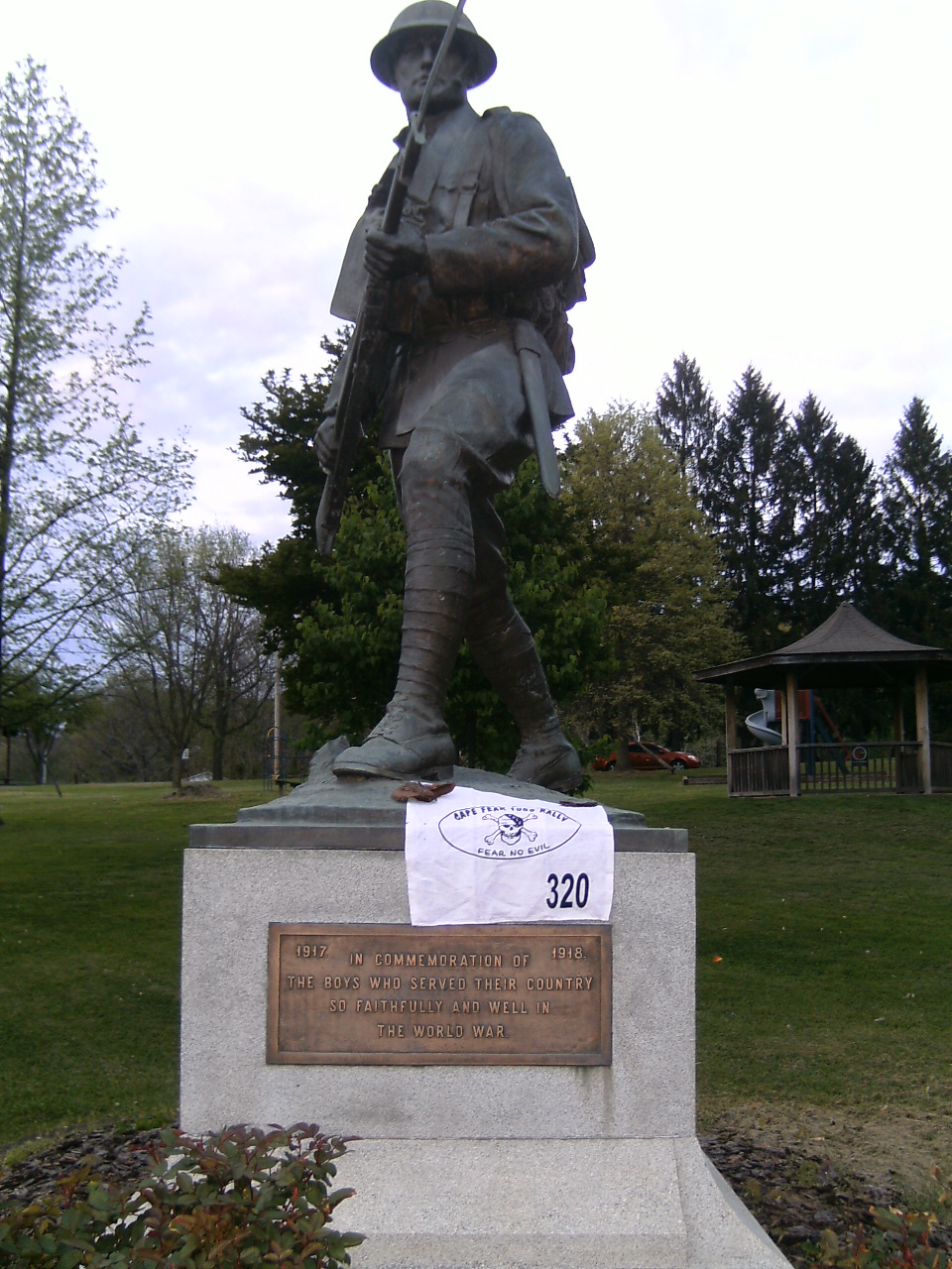
As I make my way over to Lancaster, Ohio, Ms. Garmin keeps telling to go north into Columbus and then head out south.  No way.  The farm roads of Southern Ohio are usually well kept and straight so passing shouldn't be a problem.  I peel off I-71 and head due east. The ride over is beautiful as I pass through a couple of small farming towns, but mostly the rural farming charm of Ohio.  I pull into the Caboose bonus location at around 6:30 p.m with 540 miles down.  I am feeling really good and enjoying this ride.  So I continue to press on eastward towards a small town called McConnelsville.  I have to back track a little through Lancaster, but traffic is light so I am making good time.  Until I get to the eastern part of the city.  There must be 50 vehicles pulled over to the side of the road ahead of me.  The travel lane is still open and clear, but something is up ahead.  As I make my way to the front of the queue, I realize that they are all queued up for the gates to open for the Drive-In theater.  A truly midwestern experience.  The rest of the trip over to McConnelsville is easy and I find the World War I statue just outside of town without delay.  Again, I am impressed at the small, simple nature of another rural town.  By now, it is almost dark and I am 600 miles into the madness.

From McConnelsville, my plan is to head over to I-77 and down through West Virginia.  I really don't like riding mountains at night so I figure staying on I-77 is going to be a safe bet.  Though Ms. Garmin really doesn't want me to hit I-77 until I go through Marietta and Parkersburg.  I buck her directions and make up my own route over the low lying mountains of Southern Ohio.  Although she stays mad at me the entire way and constantly recalculates the route, by the time I hit I-77, Ms. Garmin realizes that I really haven't lost any time. and she says I should be in Beckley, WV for the next stop a little after 10:30.  So I settle in for a simple zip down the interstate.

Just before I reach Beckley, I peel off I-77 to head over to a miner memorial statue in Oak Hill, WV.  The instructions for the memorial are very specific and you must have the miner, the mine cart and the base of the statue in your picture.  So after fiddling with the camera settings and positioning my bike to light up as much of the statue as I can, I wind up with the following picture.  I think mission is accomplished.  From Oak Hill it is back on I-77 to Wytheville, VA and the Super 8 Motel that I have reserved.  I still get a lot of grief for reserving rooms for my rest bonus before the start of the rally by many.  But it works for me, and I enjoy the fact knowing that a room and bed are awaiting me when I get to where I need to be.  The process has only really bite me once when I reserved a room too far out during last year's Cape Fear. The rest bonus has to start after 12:01 am.  So my schedule has me pulling in at 12:16, seems just about right.  I arrive with 853 miles down and I settle in for a nice 6 hour break.  Sleep doesn't come easy, but after an hour it does and I sleep soundly until 5:30 when the alarm goes off.  I take a quick shower, reload the bike, and grab a ending rest receipt for 6:13 a.m. - so that means I have a 5 hour and 57 minute rest.  I will lose 150 points for not taking the full 6 hours.  I hope that doesn't come back to bite me.  Probably should have gotten another receipt, oh well.

Just before 7:00 a.m. I am routed onto the Blue Ridge Parkway for the Blue Ridge Chapel bonus.  Getting it is easy, but the route Ms. Garmin sends me to get back to I-77 is not for the faint of heart.  Thankfully, it is daylight and I can see where I am going and to stay off the dirt roads that she wants me to explore.  I know many riders probably hit this late last night.  I am glad I can see where not to point the bike as the road seems to simply send me falling off the mountain. All is fine and I settle in for a beeline of interstate travel to the required odometer check on I-40 just past I-95.  I pull into the odo check right on schedule at 10:00 a.m. and complete the 19.2 mile odometer check in 19:12.19.   Part of the challenge was to do the odometer check with the same time as the average for all riders.  Though I followed all laws and speed limits, I caught the traffic signal coming off the ramp and feel that I may have finished a little quick. I have now completed 1,140 miles and suspect that I have about 200 more to go before 3:04 p.m.

Now it is decision time, I have time to hit the two higher point locations northeast of the odometer check or I can head south towards North Myrtle Beach.  Although I feel that I can and should do the higher locations, I decided to stick with the ride plan since it has worked so well for me so far.  Off towards Elizabethtown I head. Elizatbethtown is the home to a Space Shuttle pilot and they have a beautiful mural painted in his honor.  From there it is back roads into North Myrtle Beach.  The thing about the Myrtle Beach area is to know how to get around without being on US 17.  Before the rally started, I found out that the bonus location was located on US 17 - but near a brand new crossing of the intercoastal waterway.  So I figure I can stay inland until the crossing hit the bonus and head back out without seeing much traffic.  That is exactly what I do and I hit the putt-putt course actually ahead of schedule at 12:50 p.m. and 1,250 miles into the ride.

The ride up into Wilmington is simple enough (thank goodness for Hickman Road) and after a quick stop for a six pack for the dinner.  I arrive safe and sound at the Greentree Inn at 2:04 p.m with 1,335 miles.  I have never ridden so many miles in a 29 hour rally before and yet I still leave 60 minutes on the clock.  I probably should have done the other locations, but am very pleased with my ride.  I did everything that I wanted and now I will be scored to see how things progress.  Scoring is easy - everything is in order and I wind up with almost 39,000 points.  I did lose 150 for the rest bonus being less than 6 hours and another 180 for being too quick on the odometer check.  I wind up 13th of 42- unlucky or not, I am happy with it.  I do lose to Rick and Barbara - who rode about 200 miles less than me.

There are a lot of would've, could've, should've discussions over dinner.  But it is fun seeing so many friends and comparing notes.  Really the dinner at the end of the event is really what these things are about in my opinion and I linger longer that I probably should trying to say hi to as many people as possible that I have come to know over the years.  There is never enough time to see and talk to everyone.  One thing is for certain - Jim and the rest of the Rally Krewe put on a great event and one that never disappoints.  Thank you Jim.

I head out first thing on Sunday (in between rain showers - it is Cape Fear after all) to spend a few days with Mom in Southport before heading back to Athens on Tuesday.  On the way home, I hit another Tour of Honor location in Augusta so I am now 3 down with 4 to go.  This is turning out to be a great tour with some really incredible looking memorials.

Overall, it was a good 10 days of riding- due to a number of reasons, I haven't gotten to ride much this spring and it feels great to put over 3,000 miles on the bike in such a short time.

The satellites seem to keep up with me fairly well over the days (including the training ride the week before) and can be seen at this link :
http://spotwalla.com/tripViewer.php?id=44b14f82e6ae41105

which kinda looks like this:


Saturday, April 14, 2012

April 11, 2012 - Ready for Cape Fear

Decided to play hooky this day to do an easy 650 miles in about 12 hours while trying out the set-up on the bike for the upcoming Cape Fear rally.

The ride out of pre-dawn Athens was simple. Heck even traveling through downtown Atlanta at 6:00 a.m. was a piece of cake. I don't think I dropped below 60. Rolled into Villa Rica right off I-20 shortly before 7:00 a.m. and easily found the mural needed as part of the Tour of Georgia ride. Now that most of the interstate riding is behind me, the fun can begin as I make my way down the western portion of the state.

It is a pretty direct shot down a few Georgia state highways between Villa Rica and La Grange where two different locations for two different summer rallies/tours happen to be located. The first stop is an Historical Marker for the Nancy Harts. This is my first location collected as part of the Tour of Honor ride that I am doing in support of the Wounded Warrior project. The location is easy enough to fine - but faces due east. Given the rising sun, my camera really had a tough time exposing the shot. But I think it is good enough for the tourmaster's review so I head a block south to the fountain in the middle of the town square. It really is a beautiful square, lined on all four sides with trees and a nice wrought iron fence. It would be great if Athens had something similar. But the college kids would probably just destroy it any way - kinda like they have with most of downtown (but that would be the subject of another post).

From downtown LaGrange, Ms. Garmin routes me through a neighborhood and then right onto I-185 south. I don't remember Streets and Trips having the same route, but this one was certainly easy. The rest of I-185 is the typical boring straight and fast ride down to Columbus. I really hate riding through Columbus, but the Georgia Tour has the next spot just off the Interstate so it was a quick stop for gas and next picture. If all of my trips into Columbus would be this easy. From Columbus it is over to Plains. I am really looking forward to this stop since I have never been to Plains before and have come to admire a ot of what Jimmy Carter has done since leaving office (I was only in elementary school during his Presidency, so I really can't comment on what he was like as a President - but I would challenge you to name another former President that has done so much throughout the world as Mr. Carter has).

The ride into Plains really starts to reveal South Georgia. The small towns that time has almost forgot and the large expanses of farmland that dot the landscape. Coming into Plains, it is clear that Plains would be just like the other towns if it wasn't for the Carters. However, even with their presence, the town is pretty sleepy and still appears to cherish a simple existence. The stop in front of the Giant Peanut from Indiana is easy enough to find. So I point the bike even further south.

The next stop is a giant mural on some grain silos in the small town of Colquitt about an hour south of Plains. More of the same landscape has you head further and further into South Georgia. Even though most of the state highways here are just two lanes. There is so little traffic that even when you do find yourself behind someone, it is about 20 seconds before you can pass. Since it is still early spring, the fields are alive with activity of the various planting rituals. So the scenery is quite interesting to watch - though the only real thought that goes through my head is that I am glad that I am not a farmer. Watching the plume of dust that follows the tractor through the fields clearly show how hard and dirty farming is. Finding the mural in Colquitt should have been a piece of cake, but I missed it on my first pass through town. Sometimes you really need to get your eyes off the GPS and simply look up. The size and detail of the mural was impressive. Again, my camera was unhappy in trying to figure out what to focus on - either my passport book or the mural. So I think it wound up with something in between - which caused both the passport and mural to be a little out of focus. So, the picture really doesn't do the detail and color of the mural justice.

The next stop was an Elephant marker in a grave site over in Moultrie. Again, a simple hour ride over to Moultrie. Nothing really of note to pass on through the ride east. Pulled up to the grave site and snapped the picture and moved on. Shortly after getting back on the highway, I come across a pretty ugly accident, looks like a small sedan pulled out of a side street in front of a pick-up truck. The impact looked like it launched the sedan into the roadside ditch before sending the vehicle airborne into the field where it landed on it's roof. There were enough state patrol and EMS works on the scene, so every vehicle coming onto the scene were quickly being rushed through the site. Surprisingly enough, it didn't look like anyone was seriously injured given the general body language of the emergency workers. I hope that was the case.

The last couple of stops for the day were just off I-75. Another city fountain in Nashville, GA followed by Bear in Macon. Finding both locations were pretty simple - again once I stopped exclusively relying on Ms. Garmin to tell me what to do. Coming up out of Macon was simple, I did pass another Georgia Tour location at Rock Eagle but didn't stop since that location was planned to be bagged as part of the later coastal ride that I have planned. The only traffic to speak of during the entire trip shows up in Oconee County where they are resurfacing US441. It has been a cluster since they started a few weeks ago. The only good part of the project is that the weather has allowed them to stay ahead of schedule.

I make it back into Athens in just under 12 hours - for 652 miles. I stayed on schedule the entire ride and once again proved to myself if I simply "Plan the Ride" and then "Ride the Plan." Advice that I must adhere to in the upcoming Cape Fear if I want to be competitive - which I do.

Tuesday, October 11, 2011

A Podium Finish ... really .... me?

The 6th Annual Void Rally - October 7-8, 2011

I have sat through a fair number of after rally banquets over the past four years and have always been amazed at the accomplishments of the podium finishers. Although I have secretly strived to be one, I was pretty much resolved to the fact that I will probably never make it there. I thought that I just don't ride aggressive enough, but this past Void Rally proved to me that you don't have to ride overly aggressive to place in the top three. Others have said it, and I never truly believed them, but if you plan a good route, execute it exactly as planned, and just ride smart over the entire rally, just about anyone can bring home a trophy. I now understand that.

The riding weekend actually began on Thursday morning as I left Athens for the Void 6 start in Albany. Earlier this summer, I partook in the Tour of Georgia fundraiser for the Lions Club Summer Camp and completed 16 of the 19 possible Georgia First locations (you only needed 16 to be deemed a finisher). More out of a sense of accomplishment, I decided to use the trek down to Albany to hit the three Georgia First locations in the western part of the state (Griffin, Columbus, and Shellman). The trip was only going to add about 70 miles and the weather was going to be beautiful, so I decided to bag them. The HHM in Griffin documented the fact that Spalding County was the first county between Chicago and Miami that had a continuous concrete roadway on what is referred to the Dixie Highway back in 1919. Something that is pretty amazing considering Spalding County was extremely rural back then (and probably not that well off financially).

After the stop in Griffin, it was over to Columbus. Not much traffic or development in this part of Georgia, but the rolling nature of the topography is really something I enjoy riding through. Although most of the routes were two-lane, I was making great time. The major disappointment was when I stopped to get gas, I noticed that I had "attracted" a Dremel grinding stone from my garage floor to the bottom magnets on my the tank bag (I had taken the tank bag off after the Georgia In-State ride and put it back on Thursday morning). So the past 150 miles the slight vibration of the tank bag allowed the grinding stone to do a nice number on the gas tank's paint job. Pulling into Columbus right before lunch, exposed me to the typical traffic of any city as I traveled the local streets to the First Black Combat Aviator marker.

After a quick lunch at Arby's, I made the rest of the trip down into Albany with a brief stop in Shellman and it's City Hall, the home of songwriter Boudleaux Bryant (The Everly Brothers would still be unknown if it wasn't for Boudleaux and his wife Felic). As I drove through the quiet streets, I wondered what it is like to live in one of these sleepy, rural Southern Georgia towns. Some of the homes from yesterday are amazing to look at as you drive by and you wonder how people can afford to keep them up.

I pulled into the hotel a little after 4:00 p.m. and attended to the last minute details (a quick trip to Wal-Mart for tank bag food and a quick tour of northern Albany gas stations looking for a good starting receipt). Thanks to an on-line deal that I found for the Country Inn & Suites, most of the Albany starters were staying at the same hotel. So we all met up in the parking lot for some general discussion about the pending rally while we waited to walk over for dinner at the Mellow Mushroom. I had the honor/privilege of sitting next to Karl Snell who recently placed 13th in the 2011 version of the IBR and he was more than willing to share some of the stories from his adventure plus other observations about motorcycles, riders, and rallies. Of course, most of the discussion centered around the rally locations and possible routes. It seemed that most people felt that the Group N (or the "Virginia Loop" as I was calling it) bonus was impossible since you needed to be in Danville at dawn to take the required picture of the water tower and you couldn't finish the rest of the "Loop" in time. I felt pretty sure that you could and had spend all my prep time on since Tuesday planning to do that ride, but by the end of the night, I was convinced to route out an alternative plan. So instead of having a relaxing evening, I started routing again at 9 p.m. By 12:30 a.m., I was pleased with the alternative and decided to go with that unless I got into Virginia much earlier than I was anticipating and feeling extremely well.

One of the best parts of the Void Rally is how heavily theme oriented all of the bonus locations are. This year is spooky things and water towers. So every bonus location will have one or the other (sometimes even both). The water towers had to be bagged during daylight hours, so routing and time management was critical at those locations. I learned some really great folklore along the way.

Okay - Now the fun begins. Friday morning, I get the starting receipt at 9:08 a.m. (meaning I had to be in Lynchburg at 2:07 p.m. on Saturday), call into the rally headquarters, note my odometer as 16,886 and head off to Americus. I follow John Bailey up US19 out of Albany to Americus, we arrive at 9:44 a.m. (5 minutes ahead of schedule), note the odometer as 16922, and take the required picture of the haunted Windsor Hotel (with the water tower in the background). One done, several to go.

John and I quickly part ways after the first boni and I head up to Between to grab a photo of the two water towers. Arrived at 12:35 p.m. (3 minutes ahead of schedule) with an odometer of 17088. Next, I head over to Waynesboro for another water tower. Ms. Garmin is telling me to get off I-20 and cut over on Georgia state routes. I ignore her and stay on I-20, I figure it will be about 10 miles longer, but I will be able to maintain 70 mph speeds without going through small towns or deal with school buses. I snap the required picture at 2:55 p.m. (4 minutes ahead of schedule) and have already logged 353 miles in a little under 6 hours. One of the salesman from the Ford Dealership where the water tower was located came over for a little chat. I tried to be polite as possible, explained what I was doing - easiest explanation it's a "scavenger hunt on a motorcycle", he looked over my bike, wished me well and I was off.

Next was an old relic from the slave trade days in Downtown Augusta. Zip into town and bag that one at 3:30 p.m. (10 minutes ahead of schedule) with 17270 showing on the odometer. I head out of town thinking that since I am good on time, I could afford a short break at a gas station before heading onto I-20 towards Columbia and the Longstreet Theatre. Of course after the break and about 20 minutes outside of Aiken all lanes of I-20 come to a halt. Fortunately (or maybe not), I am at an exit ramp so I take it. Most of the vehicles are turning left at the top of the ramp, so naturally (like a dumb-ass) I go right. I thought that I would be able to pick up a county road that runs parallel to I-20 jump down an exit or two and hop back on. Well, Ms. Garmin's map resolution sucks and instead of stopping at the gas station and come up with a plan, I just follow her until I work something out. That probably cost me about 20 minutes. So instead of finding the parallel route (the second left), I go about 20 miles out of my way towards the southeast (I-20 runs towards northeast here) and see a central part of SC that was not on the agenda. Lesson learned. So I finally pull into the Longstreet Theatre at 5:22 p.m. (26 minutes behind schedule now) at 17358. While in the vicinity, I see several fellow riders including Rick and Barbara out of Alabama and Jim and Donna from just down the road from Athens.

Desperate to get make up the lost time, I put my head down and become bound and determined to be back on schedule by the time I hit the NC/SC bonus location on US1. While making my way there, I go through Cheraw, SC. Why do I know this place? Then I pass the "Dizzy" Gillespie statute on my right which was a 2010 Cape Fear bonus location. It is amazing how these towns get burned into your brain during these rallies. Anyway, I pick up a Harley rider and his old lady - yes, I am being stereotypical here, but that is what they were even had the straight unbaffled pipes and enough leather to be mistaken for cows. We rotate the lead for about 30 minutes or so when I pull over to take a picture of the upcoming Historical Marker at the North Carolina state line (7:07 p.m. 11 minutes behind schedule at 571 miles). They pull over too. Seems that it is time for them to put on their helmets now that they are out of South Carolina. They notice that I am taking a picture of a sign and ask what the heck am I doing. I go through the abbreviated version and they seemed generally interested in the concept of the long distance rally. She made it clear that there was no way they were going to do one, though. From my brief encounter, I really think that they were good people, just doing their own thing, their way, on their bike. We parted ways just north of Rockingham, after passing "The Rock" (glad to see NASCAR is coming back there in 2012).

Next came Chapel Hill, NC. Of course, it was Friday night of a home football game weekend. You can imagine the traffic (both vehicles and pedestrians). The bonus point here was a cross that was on the ground next to the Dromgoole Castle - the site of a pistol duel gone horribly wrong. The street where the castle is located is lined with (easily) $1 million homes. It appears that we have attracted the attention of the local residents since a couple comes up to me and wants to know what is going on since he has seen a dozen of motorcycles taking a picture of this cross over the past hour. Again the abbreviated scavenger hunt story, and he seemed relieved. Since he says that he really doesn't trust bikers. I assure him that most of us are really good people. He smiled. Anyway, again loosing time due to traffic, I pull in at 9:21 (15 minutes behind schedule) with 17562 on the odometer.

After Chapel Hill, it was time to claim the rest bonus in Danville, VA. I had hoped to be there before 10:30 p.m., but it was closer to 10:46 p.m. before I pull into the Super 8 Motel where I had a reservation (bonehead move on my part by reserving a smoking room, but I was tired and didn't care to push the issue). Easy check-in, and with a 2:00 a.m. wake-up call, I am back on the road heading towards Lynchburg by 2:15 a.m. I have learned if you carefully take everything off in a certain order once getting into the room, you can reverse the process very quickly and get out of the room in minutes.

This year, the Rallymaster threw an interesting twist to the route planning, if you make your way to the hotel mid-rally and conduct an odometer check, all points after the odo check would be doubled. It is about an hour ride up from Danville and I arrive to start the check at 3:30 a.m. After given the instructions, a big right turn box, I head out. Five minutes into the ride, I cross over the James River and into a wall of thick fog which stays with me through most of the box. Riding a bike through fog is disconcerting since you really can't see whats in front of you and your reaction time is greatly diminished. So the check takes me longer than what an open roadway at 3:30 would typically provide, but I make it through and complete the 14.6 mile odo check in 21 minutes and head back on the road about 15 minutes ahead of schedule.

Given the relatively low bonus point locations around the hotel, the only logical route was to high tail it out and head either north or south. Since I always wanted to be in Gettysburg at sunrise, my routing plan had me head to southeastern Pennsylvania. Getting to Gettysburg from Lynchburg is not a hard ride. Ms. Garmin had me take a "shortcut" over the mountains instead of staying on the divided highway of US29 to I-64. A quick scan of the route makes me believe that it is not a bad option, even for 4:00 a.m. and it turns out to be a pretty good road. Some twisties, but none that were that tight and (of course) no traffic. Along the way I had the "normal" wildlife encounters including a doe crossing my path about 50 feet in front of me, a beautiful 8 or 10 point buck and a flock of does off the field to my right, and the occasional possum scampering across the road. I hit the interstate at around 4:30 and settle in for a 2 hour I-81 ride while waiting for the sun to rise.

Just before hitting the West Virginia line, I cut over through the northern part of Virgina to Harper's Ferry, WV and then Maryland to pick up a water tower bonus. As I am riding along the Potomac River, it suddenly dawns on me that there is a lot of fog coming up from the river valley and I hope that it isn't going to mess with the bonus picture. Pulling into Brunswick, it is clear as day with the sun shining. Looks like I am going to be okay - but then I follow the road down a slight hill to the Southern States store (required to be in the picture) and into a wall of fog. How can that be? Literally 100 feet up the road it was clear.
Typically, what the Rallymasters tell you to do in these cases, is to do as much as possible to prove and document that you were at the bonus location. So I took a picture of the Southern States sign in the fog, went around the corner and took the clear picture of the water towers, and then ran over to a store and bought a drink to get a receipt to prove that I was in Brunswick, Maryland at 7:22 a.m. This proved enough to claim the bonus. So I am now 19 minutes ahead of schedule after traveling 1028 miles in about 22 hours (another undocumented SS1k).

From Brunswick, it was a quick hop up to Gettysburg. As I arrive at Devils Den, I see Karl Snell at the bonus location. At first, I am excited to see him because he is a great rally rider and one that is always near the top of the finishers, so I thought I was on the right route. I also thought he was just about ready to take off, but then I notice that half of his bike is sprawled out on the parking lot. Not a good sign. It seems that his transmission froze on him about 30 minutes ago and his rally was over. Knowing that I couldn't help him with the mechanical side of things, I offered any other assistance that I could - a ride somewhere, food, water. But he seemed quite content staying right there, he assured me that he already had AAA on the way, had wireless internet service, and that I was burning precious time talking to him. He encouraged me to take the bonus picture and head out. So I did. Upon reflection of our brief visit, I was truly amazed as to how calm and accepting of the situation he was. I know that I would not be. He kept saying that he was fortunate that it happened there and then and not along the side of an interstate at 4:00 a.m. He has given me great advice (through words and actions) as to handle the time (and yes it will happen to everyone in one of these rallies or long distance adventure) when I get stranded somewhere. So thanks, Karl. Anyway, it's 8:19 a.m. and I am still 17 minutes ahead of schedule with an odometer reading of17964.

From Gettysburg, it is a quick ride down I-270 and I-495 to Fairfax County. Along the way I ride through the job site that I worked on 20 years ago as a surveyor. As I ride past the center bridge abutment, I glance over to the median wall looking for the benchmark that I set that summer. No clue if it was still there, but in a moment, it was 1990 all over again. Any way, Roundtree Park is just off US-50 near Falls Church and I ride in at 9:55 a.m. (13 minutes ahead of schedule) with 1,160 completed. As I leave the park, I hear a slight pop from my splitter cord to my 12 volt receptacle and then the GPS goes dead. WTF???? A quick check of all other electrical components (they all are working fine), leads me to believe that I blew a fuse. The splitter was always cheap anyway and probably shorted out. At first, I think I can finish the rally without a GPS and then sanity returned. My GPS has about a 4 hour battery so there is a chance that if I conserve power (turn it off for interstate travel), I probably could make it back to Lynchburg. So I head south on I-95.

As soon as I leave Springfield on I-95, traffic immediately starts to slow - never quite stop, but very close. Since the GPS is off, I can't tell how much time I am losing, but I know that I am losing time. When I get within a stone's throw of Fredricksburg, I hop off I-95 and over to US 1 to head to Morton's BMW to get Steve Anderson's autograph and photo. I arrive at 11:09 a.m. (now 1 minute behind schedule) with the odometer reading 18098. While there, I ask Steve Anderson if they happen to have any fuses. They don't, but I decide to check my bike just in case I have a spare 5 or 10 amp on the bike since I really feel like I am going to need the GPS to get back into Lynchburg on time. So, I play a little parking lot mechanic and lo and behold, once I pop off the seat I find a spare 5 amp fuse. I immediately remember putting it under the sear just for this possibility. So in 5 minutes, I have the fuse in, the seat on, and heading out right behind Jim and Donna Phillips who happen to have pulled in to Morton's immediately behind me.

Jim and Donna are truly exceptional rally riders and an incredible team. It is common knowledge that if your route meshes with theirs (and you can pull it off) you will be near the top. So I immediately decided to stay a respectful distance behind them, but at the same time I wasn't going to lose sight of them as we make our way back to Lynchburg. Traffic is heavy, but passable as we head towards Gordonsville for the last water tower picture. Along the way, we pass Orange County Airport, I am convinced that is where I first learned to skydive while at Virginia Tech. It was one of those places that I have not given a second thought of in 20 years, but as soon as I saw the layout of the airport and the restaurant on my right, I knew when and why I was there in the past. The Gordonsville Water Tower was an uneventful stop at 12:14 p.m. (4 minutes behind schedule) with 1,259 miles bagged so far.

The road out of Gordonsville was heavy with traffic with no places to pass. It was about a 30 minute trek down to I-64 so I had nothing to do but accept the fact that I was going to be at the mercy of the train of vehicles that I was following (Jim and Donna were now immediately behind me). Once I accepted that fact, I started noticing the scenery. It was breath taking gorgeous. Too often on these rallies, you don't get to enjoy the countryside that you are riding in. But for the next 25 minutes, I got to really soak up beauty of the Blue Ridge and Shenandoah mountains. The last stop was a simple 66 point bonus location at the Winton Country Club immediately north of Lynchburg at 1:27 p.m. (2 minutes ahead of schedule) with 18213 showing on the odometer.

After bagging the last bonus, it was a quick ride back into Lynchburg and the Quality Inn. Knowing that I was going to make it with a few minutes to spare, made the last miles much more enjoyable. I pull across the "finish line" at 1:51 p.m. (16 minutes before I needed to) with 18237 on the odometer meaning 1351 miles ridden since leaving Albany, GA 28 hours and 44 minutes ago.

The scoring process was really quite straight forward, primarily due to the index card system that I use to keep track of my bonus locations, times, and mileage while on the bike. That information is easily transferred to the rally book for scoring. I turn everything in at 2:45 p.m. and take a shower before getting scored at 4:00 p.m. The scoring process goes smoothly. The scorer has no problems or questions with my photos and documentation and I wind up with 10,237 points. He mentions to me that that was the highest he had seen from Albany. That is when I first believe that I may have done a very successful route. But then again, there were 10 different scorers and not everyone was scored yet. So, I thank him for the kind words about my route and head over to Outback for a pre-banquet snack. I meet up with John Bailey who tells me that he successfully ran the Group N bonus, since that bonus was worth 6,666 points, I pretty much believed that I was looking at the winner.

At the banquet, I am surprised to hear my name called behind John's, and Jim/Donna's for third place of 19 starters from Albany. It is really isn't a big deal and I won't be all that moody if it doesn't happen again, but that trophy looks good in my office now as Marie quickly informed me that it was not going to be in the house :-)

Sunday morning, after getting to say good bye to a number of people, but not everyone. I head down to Beth's for a brief visit with her, Travis, and the boys. They both wanted turns sitting on the bike. So there is hope for them yet.

I guess the only disappointment in the trip was how much of duplicate roads I was on this trip. I usually can make it work out that I see different routes through the weekend. But this trip had a lot of duplicates (both getting to and from the rally as well as during it). The rally season is over for 2011. Lord willing, the Cape Fear 1000 awaits me in April.

This is what SPOT saw during the weekend (including the trip down to Albany and home via Beth's):

Thursday, September 15, 2011

Sept 10th - Welcome to the IBA


Well, I finally did it.

Ever since I first became involved with long distance motorcycling, it has been my goal to properly document an Iron Butt ride. I have had a few opportunities over the past few years, but just never to the time to document the ride to the high standard that the IBA requires, so I never sent in the rides. But I was determined to check that off the list in 2011 and thanks to the MTF, I had the opportunity.

Every other year the MTF has been sponsoring regional Saddlesore rides throughout the year - typically in May, June, and September. Fortunately for me, the September ride was starting in Byron, GA (about 100 miles south of Athens). So I signed up. The ride offered two options - a traditional out and back SS1k down to Naples, FL and back on I-75 and a more challenging in-state route. Usually, the in-state routes are limited to current IBA members, but after pleading my case to the sponsor (not really, just asked nicely and gave them some reasons why I think I am qualified to ride the in-state route - mainly due to my Not Superman and Cape Fear rally experience) I was given the green light.


The ride started a little after 5:00 a.m. on Saturday as I left the Chevron in the dark heading to Columbus. It took me about 15 minutes to get into the grove of riding and comprehending what I have in front of me for the day. But, I quickly started grinding out the miles. The first check point in Columbus was an easy in and out at the pump and I headed up to Dalton via Atlanta. There was very little traffic out on Saturday morning and I made amazing time up I-185, I-85, I-285, and then I-75 - by the time I rode into Dalton, I was almost 45 minutes ahead of schedule. I then proceeded to lose a little bit of time while fooling around with the pumps and the station manager to get a good receipt before saying screw it and went next door to BP and got one. However, my left highway peg would not say up and given the fact that I was about to enter the mountains, I didn't want it down. So I rigged up a way to keep it up with velcro. I later found out it was just a stuck spring that once I cleaned it out really well it hasn't given me any trouble.

After leaving Dalton, I headed over to the mountains. I was both looking forward and dreading this part of the trip. There is nowhere else I want to ride than the mountains in the early fall, but so does everyone else. So I was expecting a fair amount of bike and vehicle traffic along US76. I didn't count on it being the Thunder over Georgia weekend. Mostly Harleys traveling in packs of about 6 bikes under the watchful eyes of the Georgia State Patrol. But it wasn't too bad, sure I lost some time like I knew that I would, but overall, I was able to keep moving. The only trouble was when I went too hot into a turn and had to use the pull-off for extra riding room. Just a dumb, inattentive mistake.


After the mountains was US441 through Clayton, down into Athens and Madison - obviously it is a route that I know well and just kept moving. The UGA/South Carolina game was the same day of the ride and I was worried about gameday traffic. There was some, but not a lot. So, I made it to the Madison check point still 30 minutes ahead of schedule.

The ride on I-20 over to Augusta was uneventful and I was able to keep up my speed. From Augusta came a back road route to a suburb of Savannah. I was taken back at the shear beauty of GA17 south of Augusta. Coming into Savannah the Spanish Moss hanging in the trees around large farming plantations was a page out of the old south.

Next was a quick jaunt down I-95 to Brunswick. I was able to pick up the UGA football game on my headset at this point of the ride so it was nice to kill the time listening to the game and rooting for UGA to blow it (they did). I did find myself in the middle of a sportsbike group on I-95 which wasn't a big deal but I can't stand the way they speed and show off. But they didn't pay me a second look.

Riding from Brunswick over to Valdosta was a reverse of the Cape Fear route that I took earlier this year - even about the same time. Given the fact that the game was still on, traffic was light on US82 and I was able to continue to make good time.


Pulling into the Shell station at Valdosta, I took a bit of a longer break than I had intended. I still was way ahead of schedule and knew all I had left was about 140 miles of interstate travel, so I lingered at the station watching the scene of people coming into and out of the station. After about 20 minutes, I headed north.

Pulling into the Chevron about 30 minutes early and seeing the ride sponsors was a great feeling. The Grubbs came over to congratulate me as I went into the store to pull together the documentation. Given the fact that it is a MTF sponsored ride, they handle submitting the documentation once they give it the once over. It will probably be a couple of months before I get the official certificate, but I am fairly certain that the receipts will be accepted by the IBA. I hung out with Quinton and Wanda for about an hour before heading across the street to crash into bed.

All in all, it wound up being about 1,030 miles in 17 hours and 15 minutes including a total amount of stopped time of 1 hour and 45 minutes. Therefore, I averaged around 59.7 mph with stops and about 66.5 mph while moving. Yeah, I guess I was moving when I was moving - but to be fair the route had over 500 miles of interstate travel (posted at 70 mph), about 400 miles of four lane divided highway (generally posted at 55 or 65 mph), and about 100 miles of two lane roadway with very little traffic on them (with the exception of the mountains).

I can see why collecting in-state certifications can become addictive. So I hope that this is the first of many in-state SS1ks for me.

Friday, July 29, 2011

July 27th - Hunting Lions in South Georgia


Sometimes the best laid plans go wrong after everything was going so right.

Since I could not do the planned ride a few weeks back, once I saw an opening my schedule I jumped at the chance to pick up the remaining 6 Lions Club stops that I needed to finish the required 16. One of the aspects of Long Distance riding that I am not completely comfortable with and need some practice is early morning riding. So I decided to use this trip as a chance to work on those skills. So off I go at 4:00 a.m.

I haven't gone 1/2 mile out of the subdivision when a family of deer decide to cross the road in front of me. Not directly, but close enough that I can easily make out individual hairs on their bodies as I pass. This is exactly why I don't like early morning riding. Though, the moon was rising late in the night (or early morning) on this day and the sliver crescent shape coming up over the eastern horizon was incredibly beautiful and it was fun to watch it slowly rise in the night sky during the first 2 hours of the ride.

I make my way over the First Georgia Welcome Center on US 301 shortly after sunrise just as planned. As much as I think it is really neat to have this building as part of our history, I question the cost to keep it running - especially since how many people (more importantly visitors) enter Georgia along US 301 these days. I am guessing it won't see the next decade.

After the Welcome Center it is down and over to the coast to visit the Jekyll Island Club. Traffic was very light on I-95 and I was making good time until my drink cup holder decided to break. I quickly make my way over to the nearest exit ramp to figure out plan B (basically shoving it into the tank bag). I elect to get off I-95 just north of Brunswick so I can ride over the bridge to Jekyll, traffic was not as bad as I feared along US 17 coming into Brunswick, but I certainly lost a lot of time. Jekyll is under construction right now so I really did not do much exploring on the island. Paid my $5, visited the phone, and then back off the island.

Going to the Lions Camp along US82 was uneventful. It is nice to see what it looks like (boring) in the daylight as compared to the midnight ride from Cape Fear. The Camp is right next to a State Park, but easy enough to get to and then back into Waycross. The smell of smoke from the swamp fires is still heavy in the air.

Just north of Waycross the weather starts to turn and a line of storms is coming at me from my left. I luckily out run them and make it into Baxley just after 12. However, the tip end of the storms catch up with me and I get wet for about 10 minutes. Nothing too serious.

Ridding through south Georgia is pretty at times and boring at others. The really small towns are quaint and the smaller cities are cookie cutter versions of each other with the same fast food restaurants and strip malls. I can't imagine what it is like living in them. Into Soperton, I head (after running through another line of storms) and are greeted by a swarm of gnats. Gotta love south Georgia. I found the news building after making a loop around the downtown area.

I am just about on schedule, maybe a little off due to fooling around with my mp3 set-up before getting into Waycross, but overall I think I should be back in Athens around 4. Even start thinking about stopping by the office. Then I get to I-16.

For the first 30 minutes, I am flying on I-16. Averaging 80+ and barely keeping up with most of the traffic. Then just west of Dublin, the traffic jam starts. I elect not to take the exit and stay on I-16. BIG MISTAKE. An hour and about 2 miles later, I slowly crawl my way through the work zone and start back up to speed. Sitting on I-16 in 95 degree weather is as bad as it can get on a bike.

I roll into Macon about an hour behind schedule, find the marker and take a picture. Though, mainly because I am cranky, tired, hot, and thirsty, I take the picture but it is blurry as hell. Instead of taking a deep breath and thinking it through, I say f*ck it and move on. The picture definitely does not meet the requirements of having your name on the passbook clearly visible, but I am going to send it in anyway. What frustrates me the most is the fact that I know better when it comes to pictures. Lesson learned since no RallyMaster would accept the crappy picture. Would you?
Anyway, I make my way out of Macon and head home. Truck traffic is heavier that I would like, but I make it home a little after 5:00 p.m. So overall 13 hours of travel to cover 650 miles. Certainly not a record, but it was a fun day.


Sunday, July 17, 2011

July 11th - 15th: Running to North Carolina


That dreaded 3:30 a.m. phone call. We all know that they exist and we all know that over time we all will get our share, but nevertheless, they are never easy. Marie, Landon, and I had a good week visit with Mom and Beth, Travis, Carter, and Austin. We get home on Sunday night and all seems well. At 3:30 a.m., Mom calls to tell us that Duane died quite unexpectedly. Well, we all know the right thing to do is to get back over there, but the question is do I leave right away or in the morning? Given the fact that Mom was just now leaving the hospital and was trying to get some sleep - leaving now and getting there around 10 really doesn't make a lot of sense. So the plan is to go into the office button up a few things and be on the road a little after 9.

Well things never go completely as planned but I manage to get out of the office a little after 11 and on the road to Mom's by 11:20. It was by far one of the fastest trips over in my 10 years of making the trip - I think the September 2002 trip over was faster only because I didn't stop at all on that one. I averaged a running speed of 73 mph the entire way and only had a 7 minute gas/pee stop in Camden. Because I was running so well on the interstate, I stayed on I-95 to US 74 instead of heading towards Conway at Florence. The distance is about 17 miles longer but the GPS says it is about 2 minutes shorter - something that seems about right. It was hot the entire way - well over 90 the entire time. I got in to a good routine of drinking every 10 minutes or so. Thankfully, it was an easy trip over and I got to my Mom's at 5:00 p.m.

After the week helping Mom as best as I could, I headed back on Friday morning at sunrise. It was a cool ride back (never got above 75) and one that I pushed about equally as hard - averaging the ride at 70 mph with just a couple of gas/pee stops due to fuel management issues. I did confirm that the Conway route is shorter in distance but slightly longer in time (mainly due to lower speeds on 501 as compared to 74). I pulled back home a little after 11:30 a.m. and headed back to the office.

I also confirmed that the motorcycle odometer is generous by about 1.44% (hey, gotta do something to keep the mind sharp while grinding out interstate miles). In other words, for every 100 miles of riding, the odometer will read 101.4, for every 300 miles it reads 304.3.

Yeah, I got to ride the bike, but I hate it for my Mom.

Tuesday, June 14, 2011

June 11th and 13th Rides


Due to a variety of work commitments, house projects, kindergarten graduations, and family vacations, I have not been able to get away on the bike for a couple of months. Not that I am complaining, it has been a good couple of months being with the family, but I missed the call of the road.

Therefore, when an open Saturday appeared and a RTE call was voiced, I jumped at the opportunity to ride over to Hickory, NC for lunch with the hope of catching a bit of the Blue Ridge Parkway. About 10 of the MTF guys met up for lunch and tire kicking. It was an easy ride up to Hickory from Athens being mostly I-85. After lunch a number of use headed up to the mountains and the Blue Ridge Parkway. Shortly before we got to the Parkway a hard rain/hail storm came upon us and we found shelter in an abandoned gas station. After a 30 minute delay, we headed onto the Parkway. The rest of the group only traveled about 10 miles before heading back to the Charlotte area. I decided to stay on all the way to Asheville. Overall, it was a beautiful ride but one filled with rain from time to time. As soon as I would dry off from the last shower, another one hit. Plus the Saturday afternoon leisure drivers were out in full - I know that the Parkway is not a private motorcycle course, but why people don't simply pull over a 10 seconds (okay 5 seconds) to allow a bike to pass is beyond me. Those few seconds would make everyone much more happy since I am sure that most don't like a bike inches from their bumper.

Overall, I think I came in about 490 miles and besides the rain storms that I had to contend with all after and early evening, it was a good day and I enjoyed the company of other MTF riders.

On Monday, Steve H. and I decided to get out and collect a few of the Lions Club passport book locations. We hit Duluth just after rush hour, but traffic was still heavy as we made our way up to Dawsonville. Once we left the Racing Hall of Fame, we traveled through Dahlonega (I had forgotten how beautiful the town is) we traveled up to Neels Gap and the Store which I had never been to before. After the Store, we hit a cemetery north of Helen before heading over to Royston and Ty Cobb's museum (why it is in a medical office is beyond me). We rolled back into Athens and hit Ben Epps just before 3 o'clock. Unfortunately, the office was calling and I needed to head in from that point. I like riding with Steve, but it is a lot of stopping (I even planned stops along the way to allow him to stretch). But it is fun to have a riding partner especially since most of the riding I do is solo stuff.


All in all, it was about 750 miles of riding over the two days. It was good to be on the bike again.